I am a PhD researcher at UCL's Centre for Advanced Spatial Analysis (CASA), The Bartlett, researching how reliable spatial evidence must be for decisions about urban heat and buildings. I study how cities are built, what they consume and who they serve. My work connects European material-flow and building-stock methods, neighbourhood care allocation and evolving research into urban form and heat. Spatial data and research software make those questions testable.
Based in London · Environmental science, spatial data and software
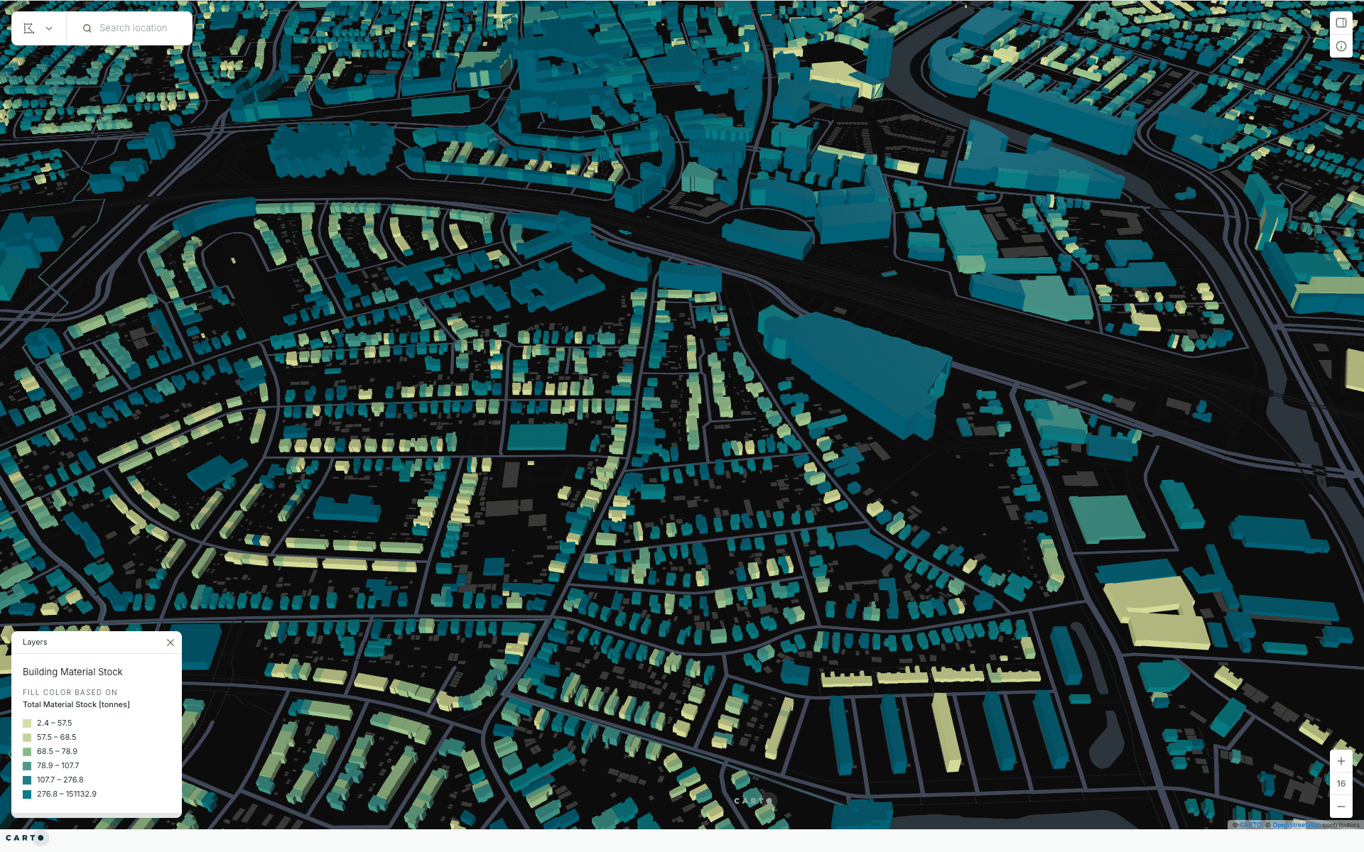
CityLoops: Urban Circularity AssessmentCompleted researchBuildings coloured by estimated total material stock, in tonnes: pale yellow lowest, dark teal highest. Apeldoorn material-stock map, 2022. Map: Gerardo Ezequiel Martín Carreño. Buildings: 3DBAG; material intensities: Sprecher and colleagues. Basemap: CARTO and OpenStreetMap contributors. Screenshot: 11 October 2026.
A co-authored method and maps estimating material stored in buildings.
Scope and limitsThe method and maps estimate urban flows and stocks from available evidence; they do not audit every tonne or survey the materials in each building. The Apeldoorn map credits 3DBAG building data and material intensities from Sprecher and colleagues. The two maps do not establish delivery of every proposed dashboard across all five pilots.
My contribution and scope
At Metabolism of Cities, I co-developed and co-authored D4.4, the Urban Circularity Assessment Method, as one of four named authors. We combined material-flow accounts for two reference years with bottom-up building-stock accounting and 18 indicators. The method specified Sankey and dashboard outputs for facilitated application in Apeldoorn, Bodø, Mikkeli, Porto and Seville. I also developed CARTO maps of building material-stock estimates for Apeldoorn and Bodø, making the stock analysis explorable at building scale. I supported application across the five pilots, built Sankey and CARTO outputs and managed two analysts.
A co-authored cartography method for nine European pilot cities, connecting local skills, materials and community networks.
Scope and limitsD2.2 documents the 2021–2022 alpha scope. The public website has evolved since then and includes later pilot material produced by the wider programme. “Urban ecosystem” refers to resources, infrastructure and social relationships, rather than a biodiversity survey.
My contribution and scope
At Metabolic, I co-authored D2.2, the Cartography Alpha Version, as one of six named authors. I helped shape a method connecting geographic context, community mapping and material flows. The report documents a clickable three-page website mock-up using Amsterdam as its example, alongside KUMU maps.
A spatial allocation study of connected neighbourhood areas for Barcelona’s home-care service.
Scope and limitsThe case documents a research method. It does not establish that Barcelona adopted the model as its final allocation or that it independently improved care outcomes.
My contribution and scope
For my double master’s thesis at UPC and my internship at BCNecologia, Barcelona’s urban ecology agency, I developed a territorial proposal for the city’s home-care service within the Superilles Socials programme. I grouped mobility superblocks around access to neighbourhood services, then aggregated blocks into functional care areas that targeted 1,400–1,800 monthly service hours; the thesis records the areas that fall outside that target. I characterised the proposal with indicators of demographic and economic vulnerability and of urban context.
Six-city urban-heat research combining satellite observations, 3D city models and street-level evidence. Model validation is being rebuilt.
Scope and limitsModel validation is being rebuilt after my own re-audit found problems in the temperature target and in how the spatial cross-validation folds were separated. Until that work is finished, no model score, explanation or cooling scenario here is a validated claim.
My contribution and scope
I built a Python pipeline joining Landsat temperature and vegetation, VoxCity 3D city models, Urbanity street networks, Global Streetscapes image semantics and EUBUCCO footprints. I generated voxel models for Amsterdam, Athens, Barcelona, Berlin, Madrid and Paris, and comparative figures for the research presentation. Exploratory XGBoost models and SHAP helped inspect associations. A later audit identified problems in the temperature target and spatial folds; I am rebuilding those stages before publishing performance claims.
Python · Google Earth Engine · GeoPandas · VoxCity